CISAR
The Combined Inversion of Surface and Aerosol pRoperties (CISAR) algorithm is an advanced mathematical method developed by Rayference for the joint retrieval of surface reflectance and aerosol or cloud single scattering properties from observations acquired by space-based imagers or drones.
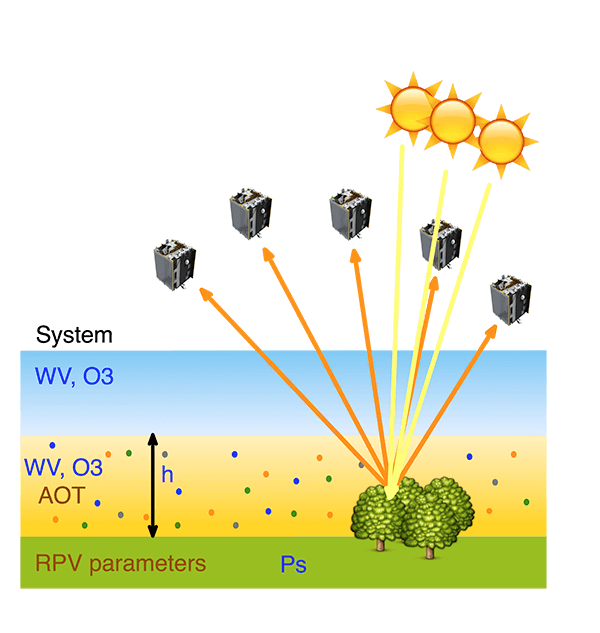
The CISAR algorithm relies on the inversion of a fast 1D radiative transfer model (RTM) called FASTRE. FASTRE describes the surface reflectance and atmospheric absorption/scattering processes as a three-layer system. The lowest level represents the surface. CISAR is applicable to any kind of surface, including water. The lower atmospheric layer accounts both for the molecular aobsorption and scattering, including aerosols and clouds. This layer is radiatively coupled with the surface for both the single and the multiple scattering. The upper layer is only subject to molecular absorption (Govaerts and Luffarelli, 2018). The sensor's observations are accumulated during the so-called accumulation period in order to form a multi-angular observation vector. The inversion takes place at the end of the accumulation period in an Optimal Estimation framework, based on Bayes' theorem. This one-dimensional variational retrieval scheme seeks an optimal balance between information that can be derived from the observations, and the one that is derived from prior knowledge of the system.
The inversion of the FASTRE model within the CISAR algorithm against satellite observations provides accurate estimates of the surface reflectance field, aerosol concentration and single scattering properties in each processed spectral band (Luffarelli and Govaerts, 2019). To overcome issues associated to cloud masking, cloud contamination and lost pixels, CISAR has been extended to the retrieval of clouds single scattering properties (Luffarelli et al., 2022). An estimate of the retrieval uncertainty is also provided following a formal mathematical framework to propagate the uncertainty (A. Sayer et al., 2020).
The CISAR algorithm has been first applied on MSG/SEVIRI observations in the framework of the ESA Aerosol_cci project to retrieve hourly aerosol properties over land and sea surfaces. It has next been applied on PROBA-V data in the context of the ESA PV-LAC study for the retrieval of surface reflectance. Following this successful feasibility study, the entire Vegetation-1, -2 and PROBA-V archive has been processed in the framework of the SPAR@MEP ESA project. The original CISAR concept has been generalised to also include the retrieval of cloud micro-physical properties within the context of the ESA CIRCAS and aerosol-cci+ projects. This development represents a major milestone as it allows the retrieval of aerosol properties without the need of an external cloud mask and reduces to zero the percentage of lost pixels, i.e. pixels not processed neither by aerosol nor cloud retrieval algorithms. Finally, MSG/SEVIRI observations acquired by both Meteosat-8 and -11 have been processed over the commonly observed area in the context of the DUST2MSG ESA project.
Do not hesitate to contact us for additonal information on the CISAR algorithm.