News
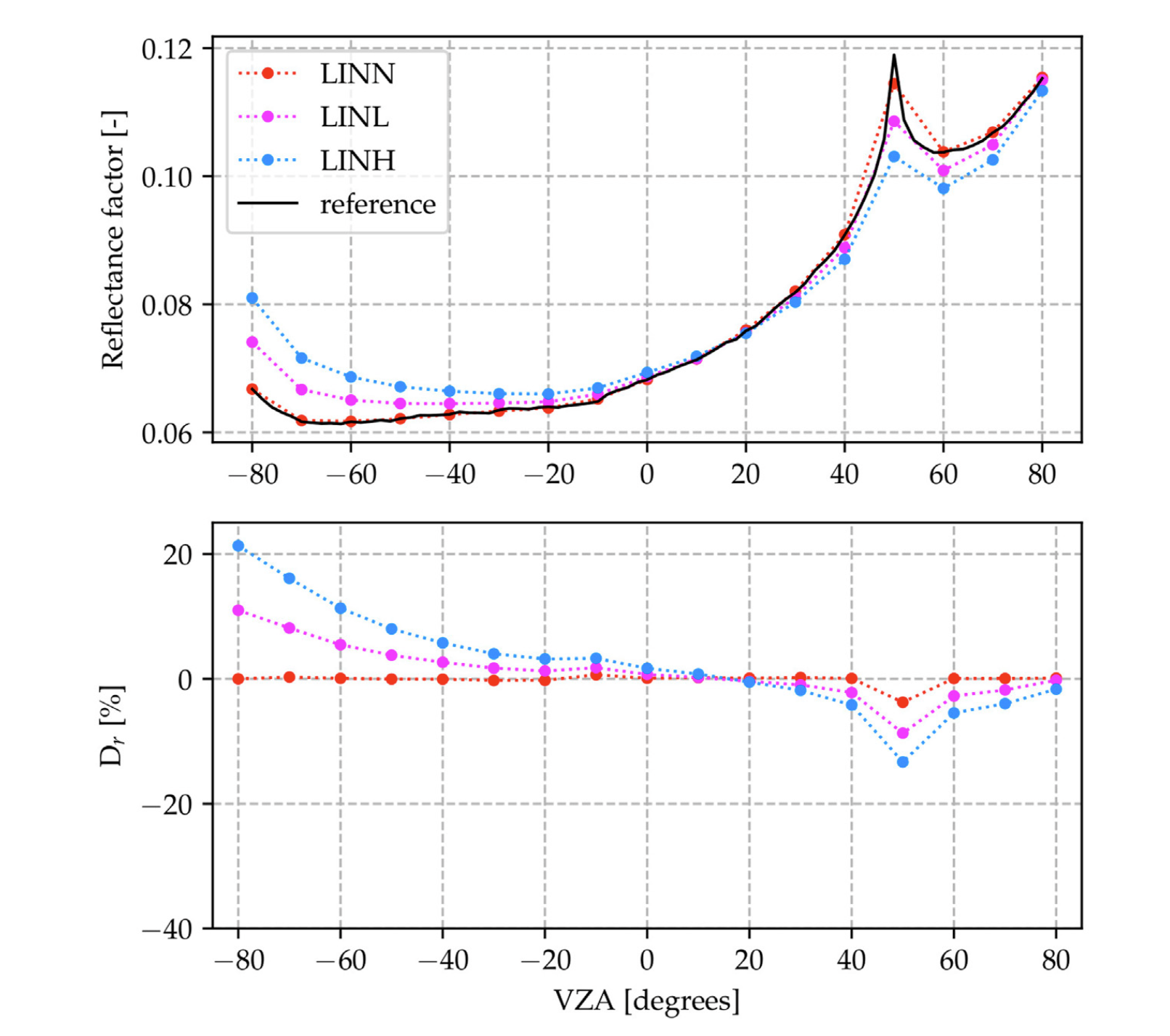
20/11/2023 Rayference first publication on UAV observation simulation with Eradiate
Our new publication on "Retrieving BRDFs from UAV-based radiometers for fiducial reference measurements: caveats and recommendations," has just been in Frontiers in Remote Sensing. This paper illustrates the difficulties to infer open-air surface BRDF from UAV observations.
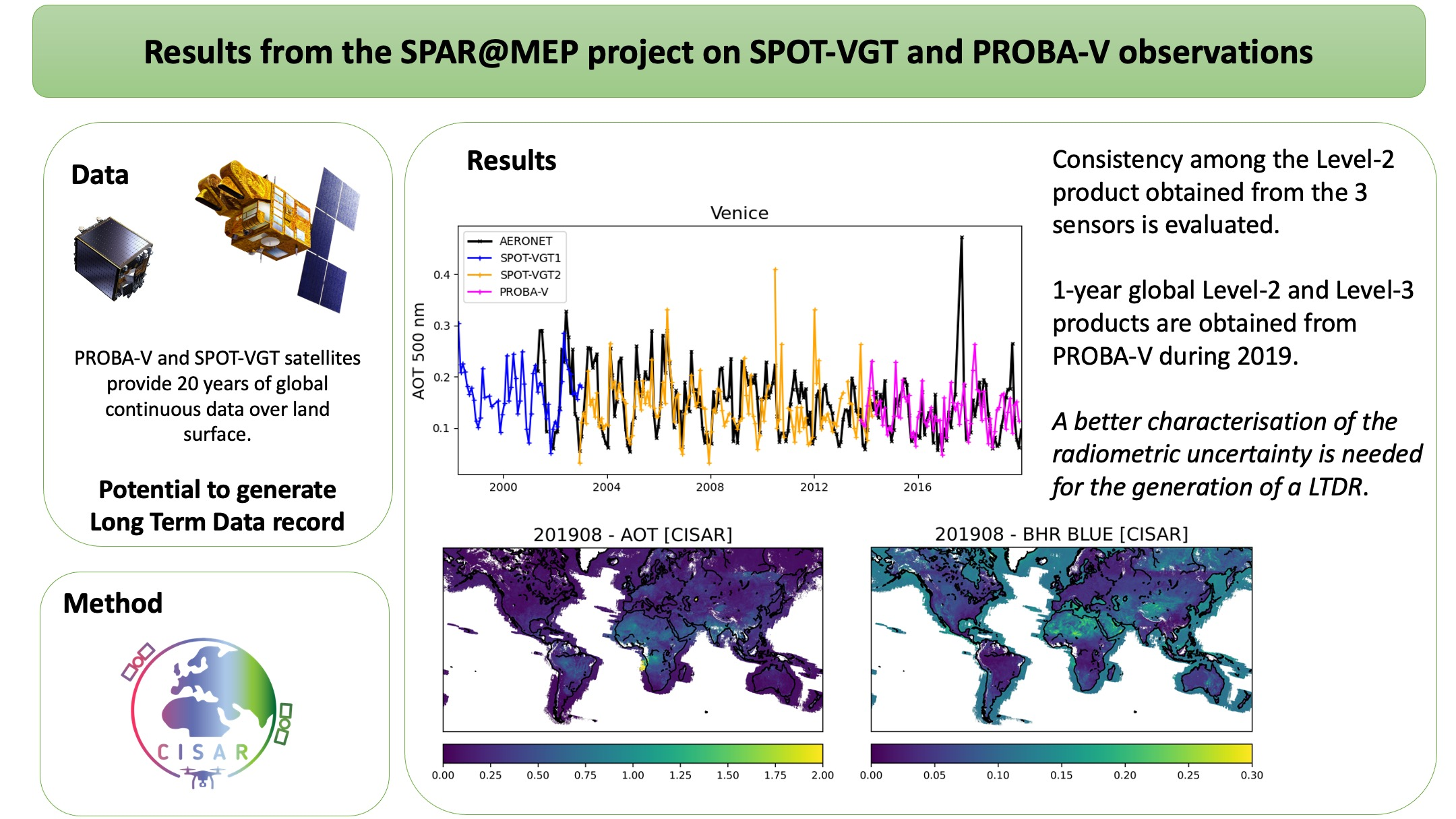
25/10/2023 Do not miss our latest results with our CISAR algorithm
Our lastest publication "Surface Reflectance and Aerosol Retrieval from SPOT-VGT and PROBA-V in the Mission Exploitation Platform Environment," has just been published in Remote Sensing. It reveals the potential of the PROBA-V and SPOT-VGT archive for the generation of climate data records.
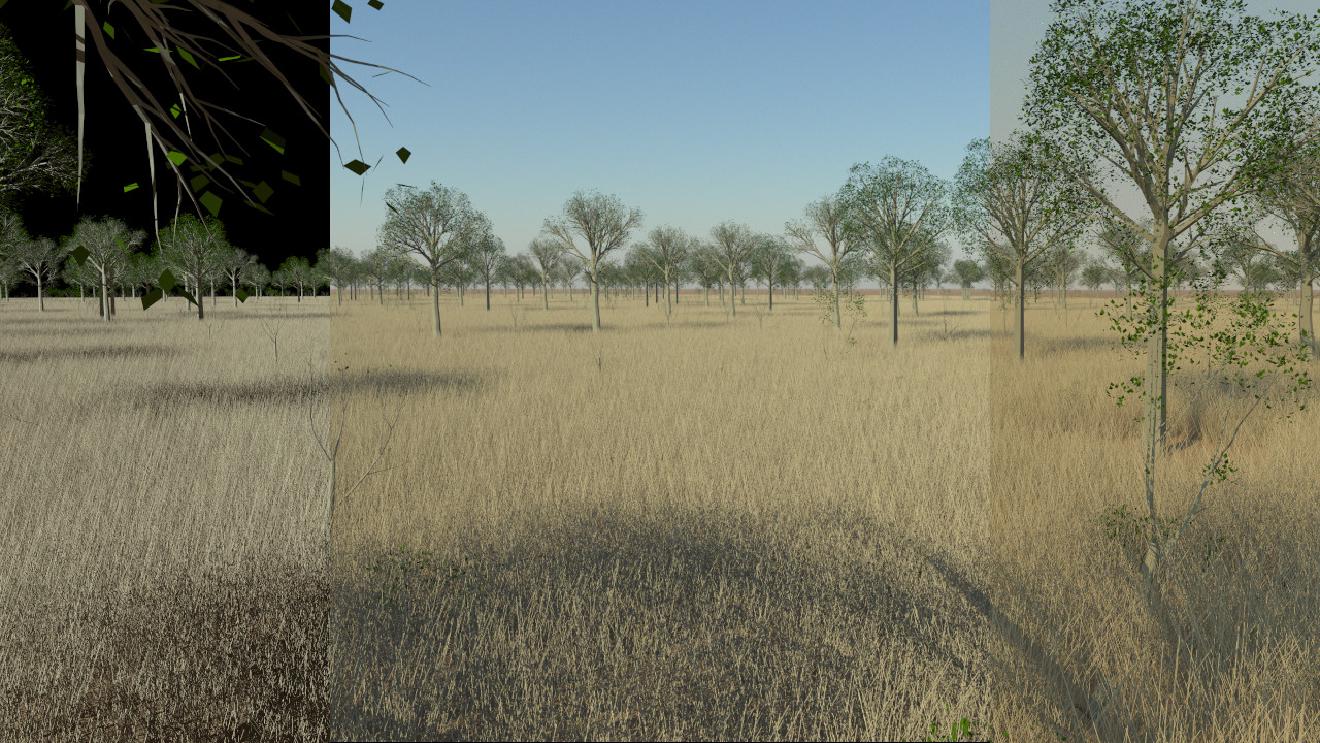
17/10/2023 Understanding the concept of surface reflectance
The lastest results obtained with our Eradiate 3D radiative transfer model illustrate the difference between black sky surface reflectance referred to as Bidirectional Reflectance Factor and the blue sky (bottom of atmosphere) surface reflectance referred to as the Hemispherical Directional Refelctance Factor.
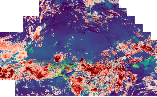
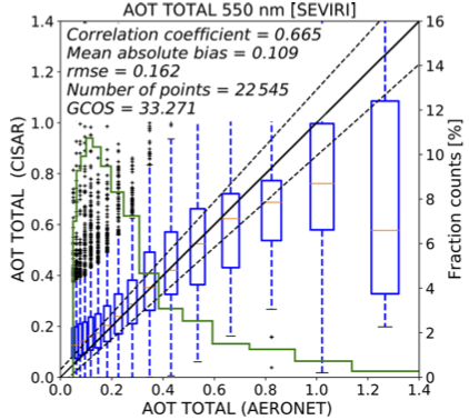
12/10/2023 Combined aerosol and cloud hourly product from satellite observations
Do not miss the latest achievement with our CISAR algorithm.
10/05/2023 Do not miss the 2023 Eradiate Workshop
We are pleased to announce that the 2023 edition of the Eradiate Workshop will take place on June 7th 2023 in Varese, Italy.
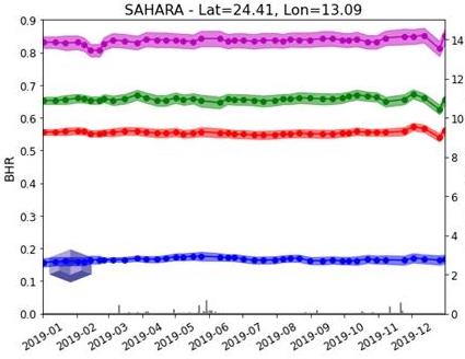
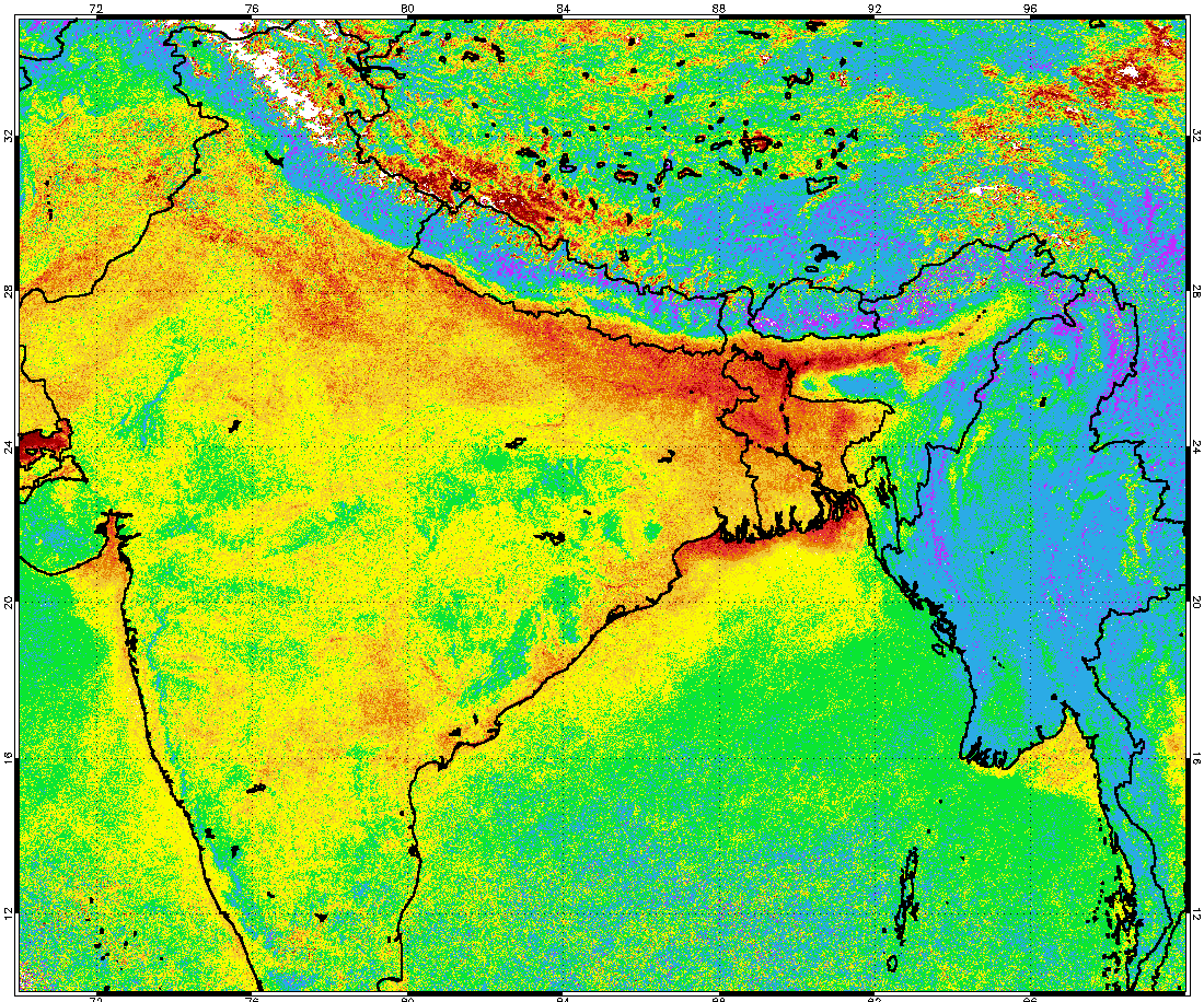
08/05/2023 On the way to derive climate data from PROBA-V
Latest results from the SPAR@MEP ESA project, applying our CISAR algorithm to PROBA-V data to retrieve an improved surface albedo over North Africa. The new global BHR dataset at 5km is available on the Zenodo repository via the following link.
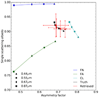
2/11/2022 Do not miss our paper of the comparison of 4 RTMs
Our last publication " Radiative Transfer Model Comparison with Satellite Observations over CEOS Calibration Site Libya-4" has just been in Atmosphere. It reveals the typical uncertainties due to radiative trnasfer model numerical approximations used to simulate satellite observations.
26/04/2022 Our last publication has been issued in Atmosphere
Do not miss our last publication from marta Luffarelli " Aerosol Optical Thickness Retrieval in Presence of Cloud: Application to S3A/SLSTR Observations" issued in Atmosphere.
25/02/2022 Registration open for Eradiate Workshop 2022
We are pleased to announce that the 2022 edition of the Eradiate Workshop will take place on March 29th and 30th 2022. The event will be hosted by the European Space Agency, if possible at ESRIN with a hybrid setup to allow for remote participation, or online should the epidemic situation prevent on-site meetings. This workshop will kick off the official release of Eradiate on GitHub.
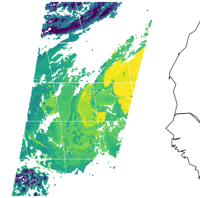
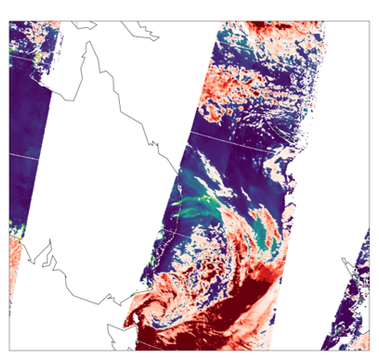
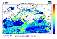
14/12/2021 Ship Trails in the Biscay Bay detected from PROBA-V 1km acquisitions with our CISAR algorithm
Ship trails in the Biscay Bay have been clearly identified from the the 1km aerosol product derived with our CISAR algorithm. Read more on this is this ESA news.

07/12/2021 Next Eradiate radiative transfer model online training session
Following the next beta release of Eradiate, we will organise an online training session for users on Tuesday December 7th 2021. During this session, we will introduce Eradiate’s atmospheric simulation features. Note that Eradiate will still be beta software at that date. Interested users are welcome to express their interest by sending an email to news-at-eradiate.eu. Please be aware that there will be a limited number of seats, to be assigned on a first-come, first-served principle.
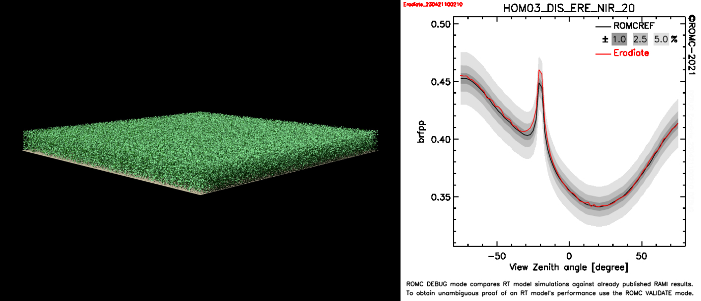
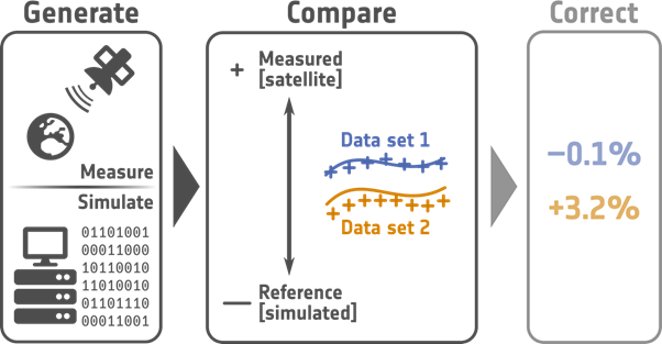
08/06/2021 One more step towards transparency and traceability of the Eradiate radiative transfer model
The development of Eradiate started two years ago with the idea of building a new radiative transfer framework designed for accuracy and usability. One of our goals is to have Eradiate recognised as a reference in terms of numerical accuracy. For that purpose, benchmarking and comparison are of prime importance: model intercomparison is how we document the strengths and weaknesses of our models and are an excellent opportunity to test and improve simulation code. Eradiate has been successfully compared with the RAMI online checker (ROMC) .
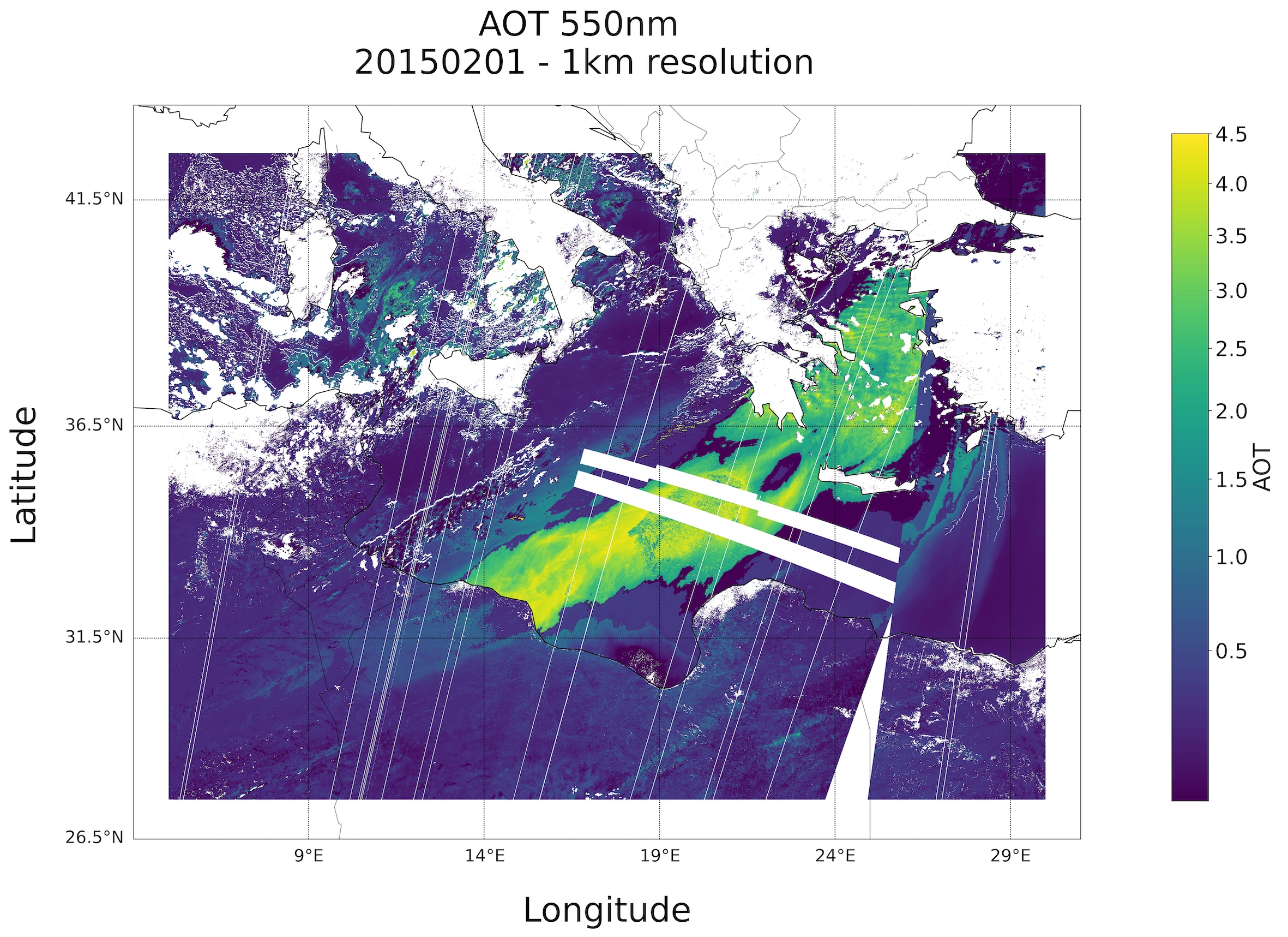
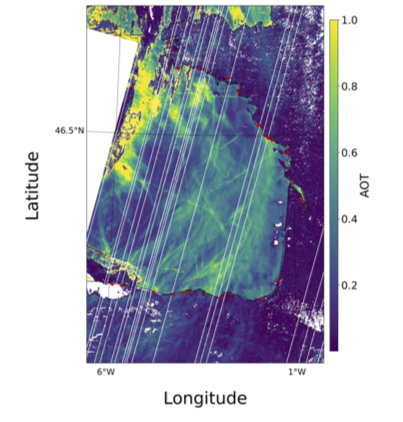
01/04/2021 1 km resolution aerosol optical thickness retrieved from PROBA-V
A 1 km r esolution aerosol optical thickness data set is retrieved from PROBA-V data from our CISAR algorithm. Read more on this topic in that ESA news.
18/03/2021 Aerosol retrieval without cloud mask
Our CISAR algorithm has been recently extended to include the retrieval of cloud properties. This was feasible thanks to the retrieval mechanism, which is based on the online inversion of a radiative transfer model. With the aid of temporal and spectral constraints, as well as a new source of prior information on the cloud phase and optical thickness built from satellite observations, CISAR is now able to retrieve aerosol and cloud single scattering properties without relying on a pre-processed cloud mask. This means that aerosols are retrieved continuously also in the presence of thin clouds. The new version of the CISAR algorithm has been applied to SLSTR / Sentinel-3A observations aggregated at 5 km. Read more on this topic in that ESA news.
10/07/2020 Towards more accurate simulation of Copernicus Sentinel optical data with our Eradiate model
The development of Eradiate model is progressing well. Read more about this activity in this ESA web story.
11/12/2019 Correction of the SLSTR solar band calibration
Rayference has been working on the verification and correction of the S3A/SLSTR solar bands. This activity has been reported in web story of the Eradiate project entitled "Estimating the accuracy of 1D radiative transfer models over the Libya-4 site". Following this study, the S3A/SLSTR Level 1b TOA BRF corrections recommended by Rayference, displayed in the following table,
| Bands | S1 | S2 | S3 | S5 | S6 |
| S3A/SLSTR NADIR VIEW | |||||
| Correction | 0.95 | — | — | 1.10 | 1.10 |
| S3A/SLSTR OBLIQUE VIEW | |||||
| Correction | 0.92 | 0.93 | 0.93 | — | — |
will be used by the CIRCAS project. These calibration correction factors should multiply the delivered top-of-atmosphere bidirectional reflectance factor (TOA BRF) values. The complete analysis is presented in a dedicated report.
20/11/2019 Eradiate Workshop 2019 Final Agenda Now Available
The final agenda for the Eradiate Workshop 2019 is now available. You can attend remotely upon request.
06/02/2019 New publication
A new Rayference publication on the CISAR algorithm has been issued: Luffarelli, M. and Y. Govaerts. 2019. " Joint Retrieval of Surface Reflectance and Aerosol Properties with Continuous Variation of the State Variables in the Solution Space – Part 2: Application to Geostationary and Polar-Orbiting Satellite Observations." Atmospheric Measurement Techniques 12 (2): 791–809.
04/01/2019 Eradiate winter news
The latest Eradiate newsletter is available here : " Eradiate Winter News ."
12/12/2018 New publication
A new Rayference publication has been issued : Govaerts, Y.M.; Ruethrich, F.; John, V.O.; Quast " Climate Data Records from Meteosat First Generation Part I: Simulation of Accurate Top-of-Atmosphere Spectral Radiance over Pseudo-Invariant Calibration Sites for the Retrieval of the In-Flight Visible Spectral Response. ." Remote Sens. 2018, 10, 1959
22/02/2018 FIDUCEO blog contribution
Visit Rayference contribution to FIDUCEO blog on "Can we trust Earth as a calibration reference for climate monitoring activity?".
17/03/2017 The CISAR algorithm
Rayference releases the Combined Inversion of Surface and AeRosol (CISAR) algorithm, an advanced mathematical method for the joint retrieval of surface reflectance and aerosol properties from observations acquired by space-based imagers.
08/03/2017 New publication
A new Rayference publication on the CISAR algorithm has been issued : Govaerts, Y. and Luffarelli, M. " Joint retrieval of surface reflectance and aerosol properties with continuous variations of the state variables in the solution space: Part 1: theoretical concept." Atmos. Meas. Tech. Discuss. 1doi:10.5194/amt-2017-29, in review.
23/08/2016 FIDUCEO blog contribution
Visit Rayference contribution to FIDUCEO blog on deriving an aerosol climate data record from Meteosat First Generation observations.
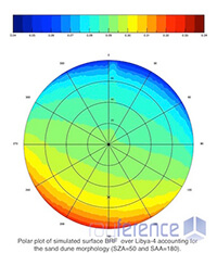
03/02/2015 New publication
In the context of the Rayference contribution to QA4ECV FP7 project, a new publication has been issued : Govaerts, Yves M. 2015. " Sand Dune Ridge Alignment Effects on Surface BRF over the Libya-4 CEOS Calibration Site." Sensors 15, no. 2: 3453-3470.