QA4EO: 3D simulations over the ESA Cal/Val Park
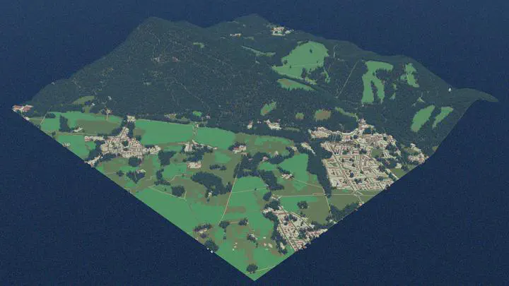 Example of a 3D scene over Tuscany generated with the DTE-S2GOS Synthetic Scene Generator.
Context
The Quality Assurance Framework for Earth Observation (QA4EO) is a CEOS-endorsed set of best practices that applies metrological principles to Earth observation, so that data and derived products come with quality indicators traceable to reference standards. Rayference contributes to this framework with a study focused on the ESA Cal/Val Park.
Most retrievals from space-borne observations rely on one-dimensional radiative transfer models, which assume a horizontally homogeneous surface. Over heterogeneous landscapes, radiation reflected by the surroundings is scattered into the instrument’s field of view and reduces the contrast between a target and its background. This adjacency effect affects both satellite and ground-based measurements, yet its impact has not been fully evaluated. Characterising it is essential to improve radiometric accuracy, and in particular to reach the demanding 1% accuracy requirement of the Copernicus CHIME hyperspectral mission.
Our approach
Rayference simulates the ESA Cal/Val Park and its surroundings in full 3D with the open-source Eradiate radiative transfer model, using the Synthetic Scene Generator developed within DTE-S2GOS. This gives a physically consistent representation of surface heterogeneity, 3D scattering and atmosphere–surface coupling, beyond the limits of conventional 1D modelling.
The study is organised in three steps:
3D scene generation. A nested 3D scene is built around the Cal/Val Park:
- the Cal/Val Park itself and its extension, including radiometric, geometric/image-quality, atmospheric and laboratory components, with masts and towers explicitly modelled;
- the surrounding landscape, generated from public geographic and high-resolution elevation data;
- a wider buffer area at medium resolution, to capture adjacency effects in satellite observations.
Sensitivity analyses define the extent of the surrounding and buffer areas. Realistic atmospheric scenarios include different vertical profiles, broken cloud fields and thin cirrus, for both summer and winter conditions.
Satellite image simulation. Front-of-telescope radiance fields for Sentinel-2 MSI and CHIME are simulated at 1 nm spectral sampling over areas of about 1–5 km centred on the park, following actual overpass geometries, together with surface HDRF. These oversampled fields can then be integrated with each instrument’s spectral response and point spread function.
Ground observation simulation. The same 3D framework is used to simulate up to five ground-based instruments operating at the park, and to compare ground- and satellite-based HDRF.
Expected outcomes
- A detailed 3D model of the ESA Cal/Val Park and its surroundings.
- Simulated Sentinel-2 and CHIME radiance fields and surface reflectance (HDRF) for different atmospheric and seasonal conditions.
- A quantitative assessment of adjacency effects on both satellite and ground-based observations.
- An evaluation of how ground measurements upscale to satellite pixels, supporting new protocols for the validation of Fiducial Reference Measurements (FRM) of surface reflectance, accurate enough to support the radiometric calibration of new missions.
Together, these results strengthen QA4EO compliance and the radiometric validation strategy for Sentinel-2, CHIME and future hyperspectral missions.
Related: DTE-S2GOS · Eradiate · Rayference for New Space